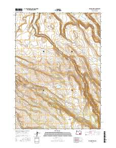
2017 Map of Krumbo Ridge
USGS Topo · Published 2017About this map
Diamond Valley opens in the northern reaches of this high-desert landscape, where the seasonal drainage of Booners Cr and Kiger Cr meets the edge of the valley floor. The terrain is defined by dramatic volcanic features like Krumbo Ridge and the distinct volcanic neck of Krumbo Butte. This area serves as a critical water management zone for high-altitude ranching and wildlife, evidenced by a dense network of water improvements such as Section Nineteen Reservoir, Frazier Lake Waterhole, and Whiskey Cr Reservoir.
Find a feature on this map
34 named features on this map. Tap any name to fly to it.
Don’t see what you’re looking for? This feature index may not catch every label — zoom into the map to look around manually.
Map Details
Editions of this 2017 Krumbo Ridge Map
This is the sole edition of this map. No revisions or reprints were ever made.
Other maps of this area

1955 · Burns
USGS Topo · 1:250,000

1955 · Adel
USGS Topo · 1:250,000

1957 · Adel
USGS Topo · 1:250,000

1958 · Burns
USGS Topo · 1:250,000

1958 · Adel
USGS Topo · 1:250,000

1959 · Burns
USGS Topo · 1:250,000

1962 · Adel
USGS Topo · 1:250,000

1967 · Happy Valley
USGS Topo · 1:24,000

1967 · Krumbo Reservoir
USGS Topo · 1:24,000
1967 · Diamond Swamp
USGS Topo · 1:24,000