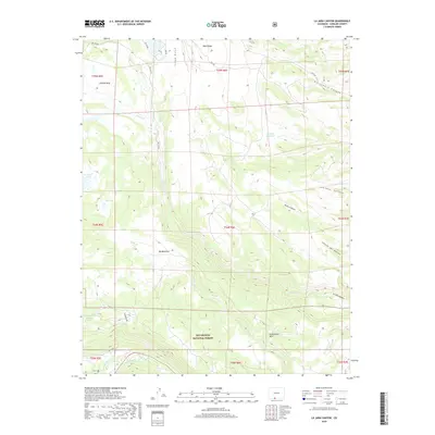
2019 Map of La Jara Canyon
USGS Topo · Published 2019About this map
The Rio Grande National Forest dominates this high-altitude landscape in Conejos County, where water management and complex drainages define the territory. The headwaters of Jarosa Cr and La Jara Cr carve through several distinct geological formations, including Ra Jadero Canyon and Leandro Canyon. High-country hydrology is represented by the massive Bluebird Reservoir and more specialized ecological features like the Chicago Bogs and Big Meadows. In the southern reaches, the Conejos River winds near Alamaditas Mesa, while numerous smaller basins like La Grulla Lake, Dry Lake, and Hidden Lake dot the plateau. The map reveals a network of Forest Service routes, such as FDR 249 RD and FDR 240, which provide the primary access for this remote portion of the southern Rockies.
Find a feature on this map
36 named features on this map. Tap any name to fly to it.
Don’t see what you’re looking for? This feature index may not catch every label — zoom into the map to look around manually.
Map Details
Editions of this 2019 La Jara Canyon Map
This is the sole edition of this map. No revisions or reprints were ever made.
Other maps of this area

1922 · Conejos
USGS Topo · 1:125,000

1945 · Durango
USGS Topo · 1:250,000

1953 · Durango
USGS Topo · 1:250,000

1954 · Durango
USGS Topo · 1:250,000

1961 · Durango
USGS Topo · 1:250,000

1963 · Durango
USGS Topo · 1:250,000

1966 · Durango
USGS Topo · 1:250,000
1967 · Osier
USGS Topo · 1:24,000
1967 · Spectacle Lake
USGS Topo · 1:24,000
1967 · La Jara Canyon
USGS Topo · 1:24,000