
1966 Map of Durango
USGS Topo · Published 1966About this map
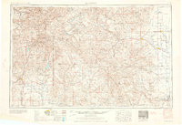
The San Juan Mountains and the high San Luis Valley dominate this mid-century landscape, capturing a region defined by high-altitude mining towns and agricultural river basins. The Continental Divide zigzags across the center, separating the headwaters of the Rio Grande from the western drainage of the Animas River and San Juan River. Settlement patterns follow the narrow-gauge path of the Denver & Rio Grande Western Railroad, which connects historic mining hubs like Silverton, Telluride, and Rico to the broader valley floor.
Find a feature on this map
268 named features on this map. Tap any name to fly to it.
Don’t see what you’re looking for? This feature index may not catch every label — zoom into the map to look around manually.
Map Details
Editions of this 1966 Durango Map
2 editions found
Other maps of this area

1889 · Largo
USGS Topo · 1:250,000

1889 · Chaco
USGS Topo · 1:250,000

1892 · Chaco
USGS Topo · 1:250,000

1895 · Largo
USGS Topo · 1:250,000

1895 · La Plata
USGS Topo · 1:62,500

1897 · La Plata
USGS Topo · 1:62,500

1897 · Rico
USGS Topo · 1:62,500

1897 · Telluride
USGS Topo · 1:62,500

1897 · Silverton
USGS Topo · 1:62,500

1898 · Durango
USGS Topo · 1:62,500