
1897 Map of Telluride
USGS Topo · Published 1897About this map
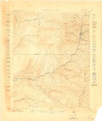
The town of Telluride sits at the heart of this high-altitude mining district, where the industrial footprint of the silver boom is etched into every canyon. This survey documents the complex infrastructure required to extract ore from the San Miguel Mountains, featuring an intricate network of aerial trams, tunnels, and mills like the Smuggler Union Mill and the Gold King Mill. Transportation is dominated by the Rio Grande Southern R.R. and its dedicated Telluride Branch, which connected remote outposts like Ames (P.O.) and Ophir Sta. to the broader world.
Find a feature on this map
162 named features on this map. Tap any name to fly to it.
Don’t see what you’re looking for? This feature index may not catch every label — zoom into the map to look around manually.
Map Details
Editions of this 1897 Telluride Map
This is the sole edition of this map. No revisions or reprints were ever made.
Other maps of this area

1897 · Rico
USGS Topo · 1:62,500

1897 · Silverton
USGS Topo · 1:62,500

1898 · Engineer Mountain
USGS Topo · 1:62,500

1898 · Rico
USGS Topo · 1:62,500
1899 · Rico
USGS Topo · 1:62,500

1900 · Engineer Mountain
USGS Topo · 1:62,500

1900 · Needle Mountains
USGS Topo · 1:62,500

1901 · Silverton
USGS Topo · 1:62,500

1902 · Needle Mountains
USGS Topo · 1:62,500

1902 · Silverton
USGS Topo · 1:62,500