
1900 Map of Engineer Mountain
USGS Topo · Published 1900About this map
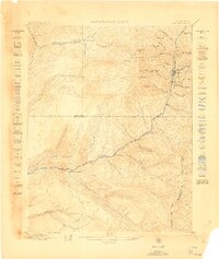
Denver and Rio Grande R. R. (Silverton Line) winds through the eastern canyon along the Animas River, a critical transportation link for the San Juan mountains at the end of the nineteenth century. This high-altitude landscape is defined by the convergence of four counties—Dolores, San Juan, Montezuma, and La Plata—meeting near the expansive Hermosa Park. The mapping shows early mountain infrastructure, including the Butler Trail and the Old Tollgate, which once facilitated movement across these high passes before modern highways.
Find a feature on this map
35 named features on this map. Tap any name to fly to it.
Don’t see what you’re looking for? This feature index may not catch every label — zoom into the map to look around manually.
Map Details
Editions of this 1900 Engineer Mountain Map
This is the sole edition of this map. No revisions or reprints were ever made.
Other maps of this area

1895 · La Plata
USGS Topo · 1:62,500

1897 · La Plata
USGS Topo · 1:62,500

1897 · Rico
USGS Topo · 1:62,500

1897 · Telluride
USGS Topo · 1:62,500

1897 · Silverton
USGS Topo · 1:62,500

1898 · Durango
USGS Topo · 1:62,500

1898 · Engineer Mountain
USGS Topo · 1:62,500

1898 · Rico
USGS Topo · 1:62,500

1899 · La Plata
USGS Topo · 1:62,500
1899 · Rico
USGS Topo · 1:62,500