
1899 Map of La Plata
USGS Topo · Published 1899About this map
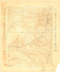
Mining operations and early railroad engineering define this 1895 survey of the high-altitude terrain where the La Plata River and various forks of the West Mancos River originate. The presence of the Rio Grande Southern R. R. winding through the southern half of the quadrangle illustrates the critical infrastructure needed to support local extraction. Significant industrial sites like the Little Kate Mill and Columbus Mine are situated near high peaks such as Diorite Peak and Hesperus Peak. Small settlements and transit points including Hesperus, Dix, and Parrott provide a look at the late nineteenth-century community structure of La Plata and Montezuma counties. The map also records early land usage at Menefee Ranch and the industrial activity at the Ute Coal Mine near Ute Junction.
Find a feature on this map
80 named features on this map. Tap any name to fly to it.
Don’t see what you’re looking for? This feature index may not catch every label — zoom into the map to look around manually.
Map Details
Editions of this 1899 La Plata Map
This is the sole edition of this map. No revisions or reprints were ever made.
Other maps of this area

1895 · La Plata
USGS Topo · 1:62,500

1897 · La Plata
USGS Topo · 1:62,500

1897 · Rico
USGS Topo · 1:62,500

1898 · Durango
USGS Topo · 1:62,500

1898 · Engineer Mountain
USGS Topo · 1:62,500

1898 · Rico
USGS Topo · 1:62,500
1899 · Rico
USGS Topo · 1:62,500

1900 · Engineer Mountain
USGS Topo · 1:62,500
1907 · Durango
USGS Topo · 1:62,500
1908 · Engineer Mountain
USGS Topo · 1:62,500