
1900 Map of Needle Mountains
USGS Topo · Published 1955About this map
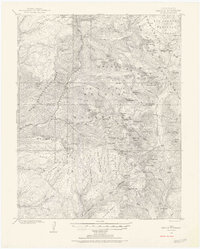
The Denver and Rio Grande Railroad snakes through the deep river canyon of the Animas River, providing the primary lifeline for high-altitude outposts like Needleton. This 1900 survey, conducted by W.M. Beaman, captures the era of industrial mineral extraction in the San Juan mountains, evidenced by the Quartz Mill near Falls Creek and the remote settlement of Beartown in the northeast. The landscape is dominated by the jagged peaks of the Grenadier Range and the Needle Mountains, where elevations like Mt. Eolus and Windom Mtn. rise sharply above glacial basins. Water management for mining or transport is visible at the Upper Park Reservoir, while the vast reach of the San Juan National Forest underscores the region's transition into a managed federal wilderness at the turn of the century.
Find a feature on this map
92 named features on this map. Tap any name to fly to it.
Don’t see what you’re looking for? This feature index may not catch every label — zoom into the map to look around manually.
Map Details
Editions of this 1900 Needle Mountains Map
3 editions found

Other maps of this area

1897 · Telluride
USGS Topo · 1:62,500

1897 · Silverton
USGS Topo · 1:62,500

1898 · Durango
USGS Topo · 1:62,500

1898 · Engineer Mountain
USGS Topo · 1:62,500

1900 · Engineer Mountain
USGS Topo · 1:62,500

1901 · Silverton
USGS Topo · 1:62,500

1902 · Needle Mountains
USGS Topo · 1:62,500

1902 · Silverton
USGS Topo · 1:62,500

1904 · Telluride
USGS Topo · 1:62,500

1905 · San Cristobal
USGS Topo · 1:125,000