1900 Map of Needle Mountains
USGS Topo · Published 1965About this map
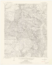
The Animas River corridor serves as the primary artery through this high-altitude landscape, tracked by the Denver and Rio Grande Railroad at the turn of the century. This survey, conducted by W. M. Beaman and E.M. Douglas, documents the remote alpine environment of the San Juan Mountains before modern access roads altered the terrain. The presence of Needleton and Beartown reflects the era's mining and railroad operations, providing essential points of reference for genealogists tracing early Colorado mountain settlers. The topography is dominated by the jagged peaks of the Grenadier Range and the Needle Mountains, where names like Chicago Basin and New York Basin suggest the origins of the prospectors who explored these drainages. Within the Rio Grande National Forest, numerous alpine lakes such as Molas Lake and Emerald Lake sit among high summits like Mt Eolus and Windom Mtn.
Find a feature on this map
86 named features on this map. Tap any name to fly to it.
Don’t see what you’re looking for? This feature index may not catch every label — zoom into the map to look around manually.
Map Details
Editions of this 1900 Needle Mountains Map
3 editions found

Other maps of this area

1897 · Telluride
USGS Topo · 1:62,500

1897 · Silverton
USGS Topo · 1:62,500

1898 · Durango
USGS Topo · 1:62,500

1898 · Engineer Mountain
USGS Topo · 1:62,500

1900 · Engineer Mountain
USGS Topo · 1:62,500

1900 · Needle Mountains
USGS Topo · 1:62,500

1901 · Silverton
USGS Topo · 1:62,500

1902 · Needle Mountains
USGS Topo · 1:62,500

1902 · Silverton
USGS Topo · 1:62,500

1904 · Telluride
USGS Topo · 1:62,500