
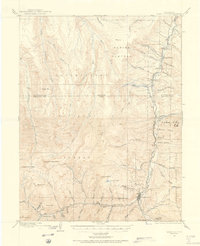
1905 Map of San Cristobal
USGS Topo · Published 1963About this map
Whitecross and Sherman stand as primary mountain settlements in this high-altitude survey of the San Juan Mountains. The landscape is dominated by the Continental Divide, which snakes through the terrain, separating the headwaters of the Gunnison and Rio Grande systems. Resource extraction and early mountain commerce are evident in the presence of Carson and the Lakemans Fishponds, while the natural topography is defined by massive peaks like Redcloud Pk and the Rio Grande Pyramid. The drainage of Henson Creek and the waters of Lake San Cristobal provide the primary geographic anchors for the northern reaches of the quadrangle. This 1904-1905 survey by J.F. McBeth records the high-country landscape during a period when mining camps and high passes like Weminuche Pass were vital links in the regional economy, long before modern infrastructure altered the accessibility of these remote basins.
Find a feature on this map
88 named features on this map. Tap any name to fly to it.
Don’t see what you’re looking for? This feature index may not catch every label — zoom into the map to look around manually.
Map Details
Editions of this 1905 San Cristobal Map
This is the sole edition of this map. No revisions or reprints were ever made.
Other maps of this area

1897 · Silverton
USGS Topo · 1:62,500

1900 · Needle Mountains
USGS Topo · 1:62,500

1901 · Silverton
USGS Topo · 1:62,500

1902 · Needle Mountains
USGS Topo · 1:62,500

1902 · Silverton
USGS Topo · 1:62,500

1902 · Ouray
USGS Topo · 1:62,500
1903 · Lake City
USGS Topo · 1:62,500

1904 · Ouray
USGS Topo · 1:62,500
1905 · Lake City
USGS Topo · 1:62,500

1907 · San Cristobal
USGS Topo · 1:125,000