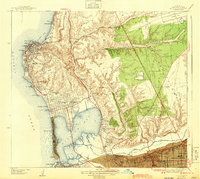
1943 Map of La Jolla
USGS Topo · Published 1943About this map
Scripps Institute of Oceanography sits prominently along the northern coastline of this 1943 survey, marking a period when San Diego’s coastal communities were transitioning from early twentieth-century resort towns into established residential hubs. The map detail highlights the development of La Jolla, Pacific Beach, and Mission Beach, where the Crystal Pier stands as a distinct landmark. Inland, the landscape is defined by the steep relief of Soledad Mtn and the broad expanses of Kearney Mesa, which at this time featured aviation sites like the Rosedale Landing Field. The infrastructure of the era is anchored by the Atchison Topeka and Santa Fe railroad through Rose Canyon and the San Diego Electric lines. Educational and institutional footprints are significant, from the Brown Military Academy to the Junipero Serra Museum Presidio Park overlooking the Mission Valley and the San Diego River.
Find a feature on this map
67 named features on this map. Tap any name to fly to it.
Don’t see what you’re looking for? This feature index may not catch every label — zoom into the map to look around manually.
Map Details
Editions of this 1943 La Jolla Map
2 editions found
Other maps of this area

1903 · La Jolla
USGS Topo · 1:62,500

1904 · San Diego
USGS Topo · 1:62,500

1904 · Southern California Sheet No. 2
USGS Topo · 1:250,000

1930 · La Jolla
USGS Topo · 1:62,500

1930 · San Diego
USGS Topo · 1:62,500

1942 · Poway Valley
USGS Topo · 1:31,680
1942 · La Mesa
USGS Topo · 1:31,680

1942 · Point Loma
USGS Topo · 1:31,680
1943 · Del Mar
USGS Topo · 1:31,680

1943 · La Jolla
USGS Topo · 1:31,680