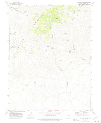
1972 Map of La Plata Canyon
USGS Topo · Published 1975About this map
The Stillwater Range dominates this Churchill County landscape, a territory defined by high elevations and essential water sources in an arid environment. In the early 1870s, the area around La Plata (Site) briefly served as the county seat, and this survey documents the remaining Ruins and topographic legacy of that short-lived silver mining boom. The map reveals a network of water points critical for survival and livestock, ranging from Mountain Well and Upper Sheep Canyon Well to high-altitude springs like Hike Spring and Burnt Cabin Spring. High peaks and deep incisions like Elevenmile Canyon and Slaughter Canyon shape the terrain, where scattered Prospects indicate continued mineral interest long after the primary settlement phase. Numerous Jeep Trails and corrals suggest the land's later transition to ranching and recreational use in the late twentieth century.
Find a feature on this map
26 named features on this map. Tap any name to fly to it.
Don’t see what you’re looking for? This feature index may not catch every label — zoom into the map to look around manually.
Map Details
Editions of this 1972 La Plata Canyon Map
This is the sole edition of this map. No revisions or reprints were ever made.
Other maps of this area

1908 · Carson Sink
USGS Topo · 1:250,000

1910 · Carson Sink
USGS Topo · 1:250,000

1957 · Reno
USGS Topo · 1:250,000

1959 · Reno
USGS Topo · 1:250,000

1960 · Reno
USGS Topo · 1:250,000

1969 · Table Mtn
USGS Topo · 1:24,000

1969 · Foxtail Lake
USGS Topo · 1:24,000

1972 · Pirouette Mtn
USGS Topo · 1:24,000

1972 · Fourmile Flat
USGS Topo · 1:24,000
1972 · Job Peak
USGS Topo · 1:24,000