1944 Map of La Plata
USGS Topo · Published 1944About this map
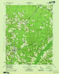
La Plata serves as the focal point for this wartime survey of central Charles County, showing the intersection of road and rail at the height of the 1940s. The Popes Creek Branch of the railroad bisects the landscape, passing through White Plains and Waldorf as it trends toward the Potomac. A significant military presence is noted at the La Plata Army Radio Sta, complete with its Radio Tower, reflecting the era's strategic communications infrastructure.
Find a feature on this map
38 named features on this map. Tap any name to fly to it.
Don’t see what you’re looking for? This feature index may not catch every label — zoom into the map to look around manually.
Map Details
Editions of this 1944 La Plata Map
This is the sole edition of this map. No revisions or reprints were ever made.
Other maps of this area

1889 · Fredericksburg
USGS Topo · 1:125,000

1890 · Mt. Vernon
USGS Topo · 1:125,000

1891 · Mt. Vernon
USGS Topo · 1:125,000

1892 · Fredericksburg
USGS Topo · 1:125,000

1892 · Brandywine
USGS Topo · 1:62,500

1894 · Wicomico
USGS Topo · 1:62,500

1894 · Fredericksburg
USGS Topo · 1:125,000

1894 · Mt. Vernon
USGS Topo · 1:125,000

1895 · Wicomico
USGS Topo · 1:62,500

1895 · Brandywine
USGS Topo · 1:62,500