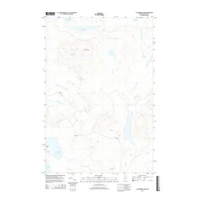
2014 Map of La Pomkeag Lake
USGS Topo · Published 2014About this map
LaPomkeag Lake and the surrounding timberlands of Penobscot County define this northern Maine landscape, characterized by an intricate network of glacial lakes and logging infrastructure. Centered on the prominent McLean Ridge, the map reveals a complex drainage system where the North Branch Wadleigh Brook and W Br Umcolcus Stream navigate the varying elevations. The southern reaches are anchored by Grand Lake Seboeis, with Pickerel Point extending into its waters near Snowshoe Lake.
Find a feature on this map
27 named features on this map. Tap any name to fly to it.
Don’t see what you’re looking for? This feature index may not catch every label — zoom into the map to look around manually.
Map Details
Editions of this 2014 La Pomkeag Lake Map
This is the sole edition of this map. No revisions or reprints were ever made.
Other maps of this area

1940 · Island Falls
USGS Topo · 1:62,500

1940 · Oxbow
USGS Topo · 1:62,500

1942 · Island Falls
USGS Topo · 1:62,500

1942 · Oxbow
USGS Topo · 1:62,500

1954 · Shin Pond
USGS Topo · 1:62,500

1954 · Grand Lake Seboeis
USGS Topo · 1:62,500

1954 · Presque Isle
USGS Topo · 1:250,000

1958 · Presque Isle
USGS Topo · 1:250,000

1960 · Presque Isle
USGS Topo · 1:250,000
1965 · Oxbow
USGS Topo · 1:62,500