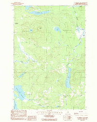
1986 Map of La Pomkeag Lake
USGS Topo · Published 1990About this map
La Pomkeag Lake and the complex drainage of the West Branch Umcolcus Stream define this northern Maine landscape in the mid-1980s. The terrain is characterized by a network of interconnected water bodies and logging camps, including Frazier Camp, Dunn Camp, and Currier Camp, which speak to the industrial and seasonal use of the region. The map captures a transitional hydraulic environment where the Umcolcus Deadwater and South Deadwater meet the headwaters of various brooks.
Find a feature on this map
35 named features on this map. Tap any name to fly to it.
Don’t see what you’re looking for? This feature index may not catch every label — zoom into the map to look around manually.
Map Details
Editions of this 1986 La Pomkeag Lake Map
This is the sole edition of this map. No revisions or reprints were ever made.
Other maps of this area

1940 · Island Falls
USGS Topo · 1:62,500

1940 · Oxbow
USGS Topo · 1:62,500

1942 · Island Falls
USGS Topo · 1:62,500

1942 · Oxbow
USGS Topo · 1:62,500

1954 · Shin Pond
USGS Topo · 1:62,500

1954 · Grand Lake Seboeis
USGS Topo · 1:62,500

1954 · Presque Isle
USGS Topo · 1:250,000

1958 · Presque Isle
USGS Topo · 1:250,000

1960 · Presque Isle
USGS Topo · 1:250,000
1965 · Oxbow
USGS Topo · 1:62,500