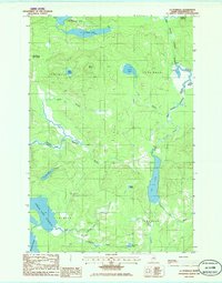
1985 Map of La Pomkeag
USGS Topo · Published 1986About this map
Grand Lake Seboeis and Cut Lake anchor this 1980s landscape in Penobscot County, where the topography is defined by a dense network of glacial water bodies and logging tracts. The area is partitioned into several unorganized townships, including T 8 R 7 W E L S and T 8 R 6 W E L S, reflecting a region primarily dedicated to timber and remote wilderness activities. Significant elevation changes are marked by McLean Ridge, overlooking the scattered wetlands of the Umcolcus Deadwater and the Lower Wadleigh Deadwater. Scattered camps such as Frazier Camp, Dunn Camp, and Foster Camp suggest a seasonal human presence and a tradition of backcountry sporting or forestry operations. The map documents the intricate hydrography of the north woods, showing how Carry Pond and Carey Lake drain through a complex system of brooks and branches toward the larger lake basins.
Find a feature on this map
36 named features on this map. Tap any name to fly to it.
Don’t see what you’re looking for? This feature index may not catch every label — zoom into the map to look around manually.
Map Details
Editions of this 1985 La Pomkeag Map
This is the sole edition of this map. No revisions or reprints were ever made.
Other maps of this area

1940 · Island Falls
USGS Topo · 1:62,500

1940 · Oxbow
USGS Topo · 1:62,500

1942 · Island Falls
USGS Topo · 1:62,500

1942 · Oxbow
USGS Topo · 1:62,500

1954 · Shin Pond
USGS Topo · 1:62,500

1954 · Grand Lake Seboeis
USGS Topo · 1:62,500

1954 · Presque Isle
USGS Topo · 1:250,000

1958 · Presque Isle
USGS Topo · 1:250,000

1960 · Presque Isle
USGS Topo · 1:250,000
1965 · Oxbow
USGS Topo · 1:62,500