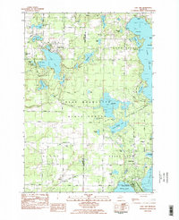
1983 Map of Lake Ann
USGS Topo · Published 1984About this map
Lake Ann and the surrounding woodlands of the Pere Marquette State Forest define this landscape on the border of Benzie and Grand Traverse counties. The early 1980s settlement pattern is anchored by the village of Lake Ann in the north and Interlochen in the southeast, where the famed Interlochen Center for the Arts is situated between Duck Lake and Green Lake. The area's glacial history is evident in the dense concentration of kettle lakes, including the sprawling Long Lake with its named landforms like Picnic Island and Brush Island.
Find a feature on this map
75 named features on this map. Tap any name to fly to it.
Don’t see what you’re looking for? This feature index may not catch every label — zoom into the map to look around manually.
Map Details
Editions of this 1983 Lake Ann Map
2 editions found
Other maps of this area

1954 · Traverse City
USGS Topo · 1:250,000

1956 · Kingsley
USGS Topo · 1:62,500

1956 · Thompsonville
USGS Topo · 1:62,500

1957 · Traverse City
USGS Topo · 1:62,500

1957 · Maple City
USGS Topo · 1:62,500

1958 · Traverse City
USGS Topo · 1:250,000

1976 · Thompsonville NE
USGS Topo · 1:24,000
1976 · Thompsonville SW
USGS Topo · 1:24,000

1976 · Thompsonville NW
USGS Topo · 1:24,000

1976 · Thompsonville SE
USGS Topo · 1:24,000
Featured Places
- Long Lake Township, MI
- Long Lake Charter Township, Long Lake Township
- Green Lake Township, MI
- Interlochen, Green Lake Township
- Hardwood Acres, MI