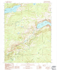
1992 Map of Lake Eleanor
USGS Topo · Published 1995About this map
O'Shaughnessy Dam anchors this high-elevation wilderness landscape, holding back the massive Hetch Hetchy Reservoir within the bounds of Yosemite National Park. This early 1990s provisional survey illustrates the rugged hydrological network of the Tuolumne River watershed, including Lake Eleanor and the dramatic vertical drops of Wapama Falls and Tueeulala Falls. Human presence is largely confined to infrastructure and seasonal outposts such as the Miguel Meadow Ranger Station, Mather Ranger Sta, and the Evergreen Lodge near the southern boundary. The map captures the intersection of managed water resources and protected wilderness, showing topographic landmarks like Kolana Rock and Hetch Hetchy Dome that tower over the granite-carved Poopenaut Valley.
Find a feature on this map
38 named features on this map. Tap any name to fly to it.
Don’t see what you’re looking for? This feature index may not catch every label — zoom into the map to look around manually.
Map Details
Editions of this 1992 Lake Eleanor Map
This is the sole edition of this map. No revisions or reprints were ever made.
Other maps of this area

1896 · Dardanelles
USGS Topo · 1:125,000

1897 · Yosemite
USGS Topo · 1:125,000

1898 · Dardanelles
USGS Topo · 1:125,000

1900 · Yosemite
USGS Topo · 1:125,000

1903 · Yosemite
USGS Topo · 1:125,000

1909 · Yosemite
USGS Topo · 1:125,000

1947 · Mariposa
USGS Topo · 1:250,000

1948 · Walker Lake
USGS Topo · 1:250,000

1948 · Mariposa
USGS Topo · 1:250,000

1956 · Pinecrest
USGS Topo · 1:62,500