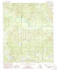
1986 Map of Lake Foursome
USGS Topo · Published 1986About this map
The winding waters of Bayou D'Arbonne define this northern Louisiana landscape, joined by numerous tributaries including Fivemile Creek, Sugar Creek, and Threemile Creek. At the intersection of Claiborne Parish and Lincoln Parish, the region shows a pattern of rural settlement and industrial activity during the mid-1980s. Local life centers around the small communities of Corinth and Crossroads, with the Corinth Cem and an additional unnamed Cem serving as important markers for family historians. Industrial footprints are prominent throughout the area, characterized by an extensive Oil and Gas Field in the northwest and a separate Gas Field to the east. In the southwest, Lake Foursome provides a distinct water feature among the creek networks of Milam Creek and Caney Creek.
Find a feature on this map
19 named features on this map. Tap any name to fly to it.
Don’t see what you’re looking for? This feature index may not catch every label — zoom into the map to look around manually.
Map Details
Editions of this 1986 Lake Foursome Map
This is the sole edition of this map. No revisions or reprints were ever made.
Other maps of this area

1950 · Ruston
USGS Topo · 1:62,500

1950 · Arcadia
USGS Topo · 1:62,500

1951 · Arcadia
USGS Topo · 1:62,500

1951 · Ruston
USGS Topo · 1:62,500

1951 · Summerfield
USGS Topo · 1:62,500

1951 · Bernice
USGS Topo · 1:62,500

1955 · Shreveport
USGS Topo · 1:250,000

1956 · Shreveport
USGS Topo · 1:250,000

1984 · Shreveport
USGS Topo · 1:250,000

1985 · Monroe North
USGS Topo · 1:100,000