2023 Map of Lake Huntington
USGS Topo · Published 2023About this map
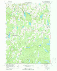
Lake Huntington and its surrounding hamlets occupy a landscape defined by an intricate network of waterways and early Sullivan County settlements. This survey highlights the dense concentration of small glacial lakes and swamps, from the expansive Lake Superior within Lake Superior State Park to smaller basins like Indian Field Pond and Lake Nianque. The distribution of burial grounds such as Kenoza Lake Cem, Fosterdale Cem, and Laurel Cem indicates long-established rural communities at Cochecton Center and Hurd Settlement.
Find a feature on this map
105 named features on this map. Tap any name to fly to it.
Don’t see what you’re looking for? This feature index may not catch every label — zoom into the map to look around manually.
Map Details
Editions of this 2023 Lake Huntington Map
This is the sole edition of this map. No revisions or reprints were ever made.