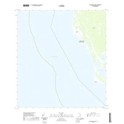
2021 Map of Lake Ingraham West
USGS Topo · Published 2021About this map
Everglades National Park meets the open waters of the Gulf of Mexico in this coastal survey of Monroe County. This low-lying maritime landscape is defined by the three distinct points of the southern peninsula—Northwest Cape, Middle Cape, and the broader reach of Cape Sable. Inland, the map documents the transition from the brackish waters of Lake Ingraham to the sawgrass environment of Raulerson Prairie. The network of tidal flows, including Little Sable Creek, illustrates the complex hydrology of The Everglades as it reaches the sea. With no road access or developed settlements shown, the map records an environment primarily shaped by natural sedimentation and coastal erosion at the southwestern tip of the Florida mainland.
Find a feature on this map
9 named features on this map. Tap any name to fly to it.
Don’t see what you’re looking for? This feature index may not catch every label — zoom into the map to look around manually.
Map Details
Editions of this 2021 Lake Ingraham West Map
This is the sole edition of this map. No revisions or reprints were ever made.
Other maps of this area

1956 · Miami
USGS Topo · 1:250,000

1958 · Miami
USGS Topo · 1:250,000

1972 · Whitewater Bay West
USGS Topo · 1:24,000

1972 · Lake Ingraham East
USGS Topo · 1:24,000
1972 · Lake Ingraham West
USGS Topo · 1:24,000

1972 · Sandy Key
USGS Topo · 1:24,000

1972 · Shark River Island
USGS Topo · 1:24,000

1981 · Cape Sable
USGS Topo · 1:100,000

1988 · Miami
USGS Topo · 1:250,000
2012 · Lake Ingraham East
USGS Topo · 1:24,000