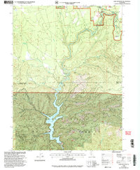
1998 Map of Lake McCloud
USGS Topo · Published 2003About this map
The Mccloud River carves a central path through the northern California landscape in the late 1990s, feeding into the prominent Lake McCloud reservoir. The area is defined by the managed waters of the Shasta-Trinity National Forest, where civil engineering and recreation converge at the Lakin Dam and its adjacent Lakin Dam Picnic Area. The river's natural descent is marked by a series of cascades including Upper Falls and Lower Falls, with supporting infrastructure like the Middle Falls Overlook providing public access to these geologic features.
Find a feature on this map
52 named features on this map. Tap any name to fly to it.
Don’t see what you’re looking for? This feature index may not catch every label — zoom into the map to look around manually.
Map Details
Editions of this 1998 Lake McCloud Map
This is the sole edition of this map. No revisions or reprints were ever made.
Other maps of this area

1886 · Modoc Lava Bed
USGS Topo · 1:250,000

1886 · Shasta
USGS Topo · 1:250,000

1892 · Modoc Lava-Bed
USGS Topo · 1:250,000

1894 · Shasta
USGS Topo · 1:250,000

1932 · Bartle
USGS Topo · 1:96,000

1935 · Dunsmuir
USGS Topo · 1:125,000

1939 · Bartle
USGS Topo · 1:125,000

1948 · Weed
USGS Topo · 1:250,000

1950 · Weed
USGS Topo · 1:250,000
1954 · Shoeinhorse Mountain
USGS Topo · 1:62,500