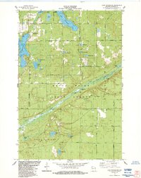
1984 Map of Lake Minnesuing
USGS Topo · Published 1984About this map
The Bois Brule River winds through the heart of this northern Wisconsin landscape, its path defined by numerous feeder sources like McDougal Springs, Blue Springs, and the West Fork. This 1984 survey reveals a transition from the structured residential blocks of Nebagamon to the protected wildlands of the Brule River State Forest and Bong State Forest. Recreation and local history are centered around the glacial waters of Minnesuing Lake and Lake Nebagamon, with Lake Minnesuing County Park serving as a primary point of public access. Genealogists and local historians can locate the Highland Memorial Cem near the intersection of Airport Road and the Bong State Forest boundary. The map further documents small-scale landmarks such as Degerman Field, the local Townhall, and the Stories Bridge Landing along the river banks.
Find a feature on this map
47 named features on this map. Tap any name to fly to it.
Don’t see what you’re looking for? This feature index may not catch every label — zoom into the map to look around manually.
Map Details
Editions of this 1984 Lake Minnesuing Map
This is the sole edition of this map. No revisions or reprints were ever made.
Other maps of this area

1945 · Highland
USGS Topo · 1:48,000

1945 · Solon Springs
USGS Topo · 1:48,000

1947 · Brule
USGS Topo · 1:48,000

1949 · Solon Springs
USGS Topo · 1:48,000

1949 · Poplar
USGS Topo · 1:48,000

1949 · Highland
USGS Topo · 1:48,000

1953 · Ashland
USGS Topo · 1:250,000

1954 · Lake Nebagamon
USGS Topo · 1:24,000

1954 · Poplar
USGS Topo · 1:24,000

1958 · Ashland
USGS Topo · 1:250,000