
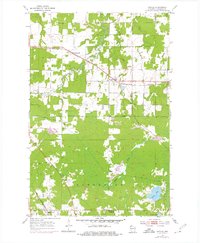
1954 Map of Poplar
USGS Topo · Published 1955About this map
The Northern Pacific railroad corridor anchors the northern reach of this Douglas County landscape, connecting the small settlements of Wentworth and Poplar. The mid-1950s terrain is defined by the winding course of the Middle River and Poplar River, which cut through a mix of wooded areas and cleared land. Further south, the community of Hawthorne serves as a local hub, situated near the Chicago and North Western line and the Parkview Cem.
Find a feature on this map
24 named features on this map. Tap any name to fly to it.
Don’t see what you’re looking for? This feature index may not catch every label — zoom into the map to look around manually.
Map Details
Editions of this 1954 Poplar Map
2 editions found
Other maps of this area

1945 · Highland
USGS Topo · 1:48,000

1945 · Solon Springs
USGS Topo · 1:48,000

1947 · Brule
USGS Topo · 1:48,000

1949 · Solon Springs
USGS Topo · 1:48,000

1949 · Poplar
USGS Topo · 1:48,000

1949 · Highland
USGS Topo · 1:48,000

1953 · Ashland
USGS Topo · 1:250,000

1954 · Lake Nebagamon
USGS Topo · 1:24,000

1954 · Poplar NE
USGS Topo · 1:24,000
1954 · South Range
USGS Topo · 1:24,000