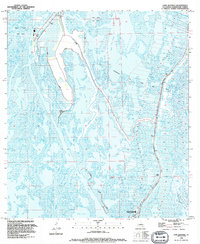
1994 Map of Lake Quitman
USGS Topo · Published 1994About this map
Dulac and Lapeyrouse sit at the center of an intricate web of waterways and marshes in this coastal Louisiana landscape. The dominance of water over solid earth is evident in the vast expanses of Lake Quitman and Lake Gero, joined by a complex network of natural bayous and engineered industrial routes. The Houma Navigation Canal cuts a straight path through the wetlands, serving as a primary artery for maritime traffic alongside older channels like Bayou Caillou and Petit Bayou Caillou.
Find a feature on this map
37 named features on this map. Tap any name to fly to it.
Don’t see what you’re looking for? This feature index may not catch every label — zoom into the map to look around manually.
Map Details
Editions of this 1994 Lake Quitman Map
This is the sole edition of this map. No revisions or reprints were ever made.
Other maps of this area

1894 · Bayou De Large
USGS Topo · 1:62,500

1894 · Dulac
USGS Topo · 1:62,500

1935 · Cocodrie
USGS Topo · 1:31,680

1935 · Theriot
USGS Topo · 1:31,680

1935 · Bourbeux
USGS Topo · 1:31,680

1935 · Montegut
USGS Topo · 1:31,680

1935 · Lake Quitman
USGS Topo · 1:31,680

1935 · Lake Gero
USGS Topo · 1:31,680

1940 · Bayou Du Large
USGS Topo · 1:62,500

1941 · Bayou Du Large
USGS Topo · 1:62,500