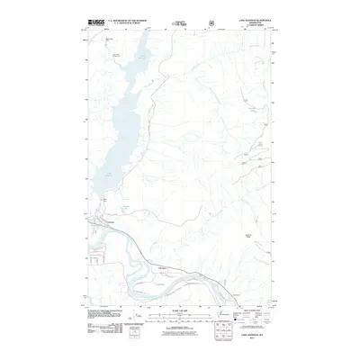
2011 Map of Lake Shannon
USGS Topo · Published 2011About this map
Lake Shannon dominates the northern landscape, its waters contained by the engineering of Bear Creek Dam and Baker Dam. This infrastructure, including the Bear Creek Powerhouse, reflects the region's long-standing reliance on hydroelectric power and water management. To the south, the Skagit River meanders through the valley, passing the settlements of Concrete and Van Horn. The map reveals a mix of industrial and residential development, with the streets of Concrete such as Railroad Ave and Main St providing a structured contrast to the high elevations of Jackman Ridge. Along the river, historical crossing points like Faber Ferry and smaller water bodies like Everett Lake provide evidence of how local transport and geography shaped these communities. The southern reaches are marked by rural roads like Concrete Sauk Valley Rd, connecting the scattered residential pockets of Mountview and beyond.
Find a feature on this map
41 named features on this map. Tap any name to fly to it.
Don’t see what you’re looking for? This feature index may not catch every label — zoom into the map to look around manually.
Map Details
Editions of this 2011 Lake Shannon Map
This is the sole edition of this map. No revisions or reprints were ever made.
Other maps of this area

1899 · Stillaguamish
USGS Topo · 1:125,000

1901 · Stilaguamish
USGS Topo · 1:125,000

1909 · Mt Baker
USGS Topo · 1:192,000

1915 · Mt. Baker
USGS Topo · 1:250,000

1952 · Lake Shannon
USGS Topo · 1:62,500

1952 · Hamilton
USGS Topo · 1:62,500

1955 · Concrete
USGS Topo · 1:250,000

1956 · Oso
USGS Topo · 1:62,500

1958 · Concrete
USGS Topo · 1:250,000

1962 · Concrete
USGS Topo · 1:250,000