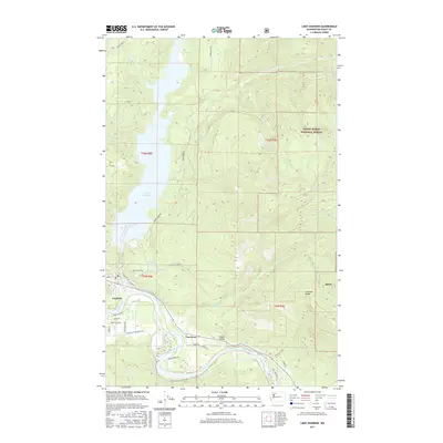
2017 Map of Lake Shannon
USGS Topo · Published 2017About this map
Lake Shannon and the winding Skagit River dominate this portion of the Skagit Valley, where the transition from riparian lowlands to the steep rises of the Mount Baker National Forest is sharply defined. The settlement of Concrete sits at the western edge of the quadrangle, serving as a gateway for the timber and hydroelectric infrastructure that shaped this region. To the east, the small community of Van Horn is situated along the river's path, near the junctions of roads like Yeager Rd and Moen Rd. The topography ascends rapidly toward Jackman Ridge and the high basins containing Thunder Lakes, illustrating the sheer verticality of the North Cascades. Numerous drainages such as Jackman Cr and Thunder Cr provide a look at the hydraulic network feeding into the main river system during this modern era of land management.
Find a feature on this map
44 named features on this map. Tap any name to fly to it.
Don’t see what you’re looking for? This feature index may not catch every label — zoom into the map to look around manually.
Map Details
Editions of this 2017 Lake Shannon Map
This is the sole edition of this map. No revisions or reprints were ever made.
Other maps of this area

1899 · Stillaguamish
USGS Topo · 1:125,000

1901 · Stilaguamish
USGS Topo · 1:125,000

1909 · Mt Baker
USGS Topo · 1:192,000

1915 · Mt. Baker
USGS Topo · 1:250,000

1952 · Lake Shannon
USGS Topo · 1:62,500

1952 · Hamilton
USGS Topo · 1:62,500

1955 · Concrete
USGS Topo · 1:250,000

1956 · Oso
USGS Topo · 1:62,500

1958 · Concrete
USGS Topo · 1:250,000

1962 · Concrete
USGS Topo · 1:250,000