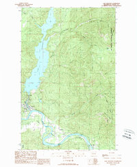
1989 Map of Lake Shannon
USGS Topo · Published 1989About this map
Lake Shannon dominates the northern landscape of this Skagit County region, held back by the engineering of the Baker Dam. This 1980s survey documents the area's transition into a recreational and conservation-focused corridor, centered on the Skagit Wild and Scenic River as it flows past the town of Concrete. The map illustrates the industrial footprint remaining in the valley, including a Gravel Pit and Quarry, which coexist with the protected wilderness of the Mt Baker National Forest. To the east, the settlement of VanHorn and the former location of Sauk (Site) sit along the riverbanks, providing a record of habitation patterns before modern conservation designations. High-elevation features like Jackman Ridge and the Thunder Lakes emphasize the verticality of the terrain surrounding the lower river valley.
Find a feature on this map
21 named features on this map. Tap any name to fly to it.
Don’t see what you’re looking for? This feature index may not catch every label — zoom into the map to look around manually.
Map Details
Editions of this 1989 Lake Shannon Map
This is the sole edition of this map. No revisions or reprints were ever made.
Other maps of this area

1899 · Stillaguamish
USGS Topo · 1:125,000

1901 · Stilaguamish
USGS Topo · 1:125,000

1909 · Mt Baker
USGS Topo · 1:192,000

1915 · Mt. Baker
USGS Topo · 1:250,000

1952 · Lake Shannon
USGS Topo · 1:62,500

1952 · Hamilton
USGS Topo · 1:62,500

1955 · Concrete
USGS Topo · 1:250,000

1956 · Oso
USGS Topo · 1:62,500

1958 · Concrete
USGS Topo · 1:250,000

1962 · Concrete
USGS Topo · 1:250,000