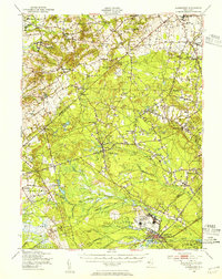
1948 Map of Lakehurst
USGS Topo · Published 1954About this map
The U S Naval Air Station and the sprawling Fort Dix Military Reservation dominate the southern landscape of this 1948 survey, reflecting the significant federal presence in the Pine Barrens during the post-war era. To the north, the terrain transitions into a dense network of small agricultural and milling settlements such as Jacksons Mills, Bennetts Mills, and Oakland Mills, many situated along the numerous branches of the Toms River and Manasquan River. The mapping captures a distinct moment before suburban expansion reached central New Jersey, showing the Pennsylvania Railroad of New Jersey cutting through Lakehurst and Ridgeway. Notable local landmarks include the State Quail Farm near Holmansville and the Jackson State Forest, alongside numerous small family-named crossroads like Carrs Tavern and Wyckoff Mills that define the historic rural character of Ocean and Monmouth counties.
Find a feature on this map
91 named features on this map. Tap any name to fly to it.
Don’t see what you’re looking for? This feature index may not catch every label — zoom into the map to look around manually.
Map Details
Editions of this 1948 Lakehurst Map
2 editions found
Other maps of this area

1884 · Whitings
USGS Topo · 1:62,500

1888 · Bordentown
USGS Topo · 1:62,500

1888 · Pemberton
USGS Topo · 1:62,500

1888 · Barnegat
USGS Topo · 1:62,500

1888 · New Brunswick
USGS Topo · 1:62,500

1888 · Princeton
USGS Topo · 1:62,500

1888 · Asbury Park
USGS Topo · 1:62,500

1888 · Cassville
USGS Topo · 1:62,500

1888 · Sandy Hook
USGS Topo · 1:62,500

1888 · Whitings
USGS Topo · 1:62,500