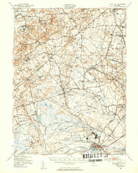
1948 Map of Lakehurst
USGS Topo · Published 1954About this map
The Naval Air Station and the eastern edge of the Fort Dix Military Reservation dominate the southern landscape of this 1948 survey, reflecting the region's mid-century military significance. To the north, the terrain transitions into a patchwork of agriculture and industry, marked by landmarks such as Wyckoff Mills and Francis Mills. This era captures the intricate network of watercourses that defined local life, from the Millstone River in the northwest to the Toms River in the southeast.
Find a feature on this map
107 named features on this map. Tap any name to fly to it.
Don’t see what you’re looking for? This feature index may not catch every label — zoom into the map to look around manually.
Map Details
Editions of this 1948 Lakehurst Map
2 editions found
Other maps of this area

1884 · Whitings
USGS Topo · 1:62,500

1888 · Bordentown
USGS Topo · 1:62,500

1888 · Pemberton
USGS Topo · 1:62,500

1888 · Barnegat
USGS Topo · 1:62,500

1888 · New Brunswick
USGS Topo · 1:62,500

1888 · Princeton
USGS Topo · 1:62,500

1888 · Asbury Park
USGS Topo · 1:62,500

1888 · Cassville
USGS Topo · 1:62,500

1888 · Sandy Hook
USGS Topo · 1:62,500

1888 · Whitings
USGS Topo · 1:62,500