
1950 Map of Lakeside
USGS Topo · Published 1950About this map
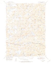
The Chicago Burlington and Quincy railroad corridor serves as the primary artery through this section of the Nebraska Sandhills, connecting the small settlements of Lakeside and Ellsworth. This 1950 survey reveals a landscape defined by an extensive network of large family-run operations, including the John Cody Ranch, Star Ranch, Joy Ranch, and Coopers Ranch. The topography is characterized by a high density of natural depressions filled by named water bodies such as White Lake, Snow Lake, and Patton Lake, which are essential for the region's cattle-ranching economy. Along the southern edge, the map identifies the Sheridan Co Garden Co line, illustrating the administrative boundaries of these remote ranching districts. Local history and genealogy are highlighted by features like the small Cem near the tracks, which provides a tangible connection to the early families who settled this distinctive terrain.
Find a feature on this map
50 named features on this map. Tap any name to fly to it.
Don’t see what you’re looking for? This feature index may not catch every label — zoom into the map to look around manually.
Map Details
Editions of this 1950 Lakeside Map
2 editions found
Other maps of this area

1896 · Browns Creek
USGS Topo · 1:125,000

1899 · Browns Creek
USGS Topo · 1:125,000

1948 · Bingham
USGS Topo · 1:62,500

1948 · Antioch
USGS Topo · 1:62,500

1948 · Lakeside
USGS Topo · 1:62,500

1948 · Twin Lakes
USGS Topo · 1:62,500

1948 · Spade Ranch
USGS Topo · 1:62,500

1949 · Mumper
USGS Topo · 1:62,500

1949 · Antioch
USGS Topo · 1:62,500

1950 · Twin Lakes
USGS Topo · 1:62,500