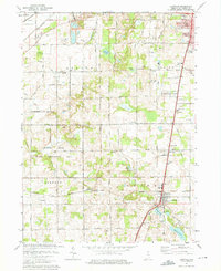
1974 Map of Lakeville
USGS Topo · Published 1975About this map
The Old Indian Treaty Boundary slices diagonally across this mid-1970s landscape, a historical surveyor's line that still dictates the orientation of many land parcels in St. Joseph County. This area south of South Bend is characterized by a mix of agricultural fields and significant glacial water bodies, including Riddles Lake, Wharton Lake, and Moon Lake. The transition from rural to suburban is evident in the development of Gilmer Park and the establishment of the Potato Creek State Recreation Area, which occupies a large portion of the southwestern quadrant. Transport networks are dominated by the Penn Central and Norfolk and Western railroads, which converge near the town of Lakeville. Local genealogy is well-preserved through numerous community landmarks such as the Sumption Prairie Ch, Greene Twp Sch, and several cemeteries including Mount Calvary Cem.
Find a feature on this map
57 named features on this map. Tap any name to fly to it.
Don’t see what you’re looking for? This feature index may not catch every label — zoom into the map to look around manually.
Map Details
Editions of this 1974 Lakeville Map
2 editions found
Other maps of this area

1953 · Chicago
USGS Topo · 1:250,000

1957 · Chicago
USGS Topo · 1:250,000

1958 · South Bend East
USGS Topo · 1:24,000

1958 · South Bend West
USGS Topo · 1:24,000

1958 · Lydick
USGS Topo · 1:24,000

1958 · Bremen
USGS Topo · 1:24,000

1958 · La Paz
USGS Topo · 1:24,000

1958 · Walkerton
USGS Topo · 1:24,000

1958 · North Liberty
USGS Topo · 1:24,000

1958 · Lakeville
USGS Topo · 1:24,000