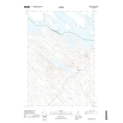
2018 Map of Lambert Lake
USGS Topo · Published 2018About this map
The borderland between Washington County, Maine, and Canada is defined by high peaks and an intricate network of glacial waterways. This survey of the region captures the settlement of Lambert Lake situated along the water, where local transit is facilitated by routes like Old Schoolhouse Rd and Walker Brook Rd. The landscape is dominated by significant elevations such as Tomah Mtn, Vance Mtn, and the curiously named Pirate Hill. These heights shed water into numerous drainage systems, including Little Simsquish Brook and Crooked Brook. Along the northern edge, the international boundary cuts across a series of coves, including Muncy Cove and Walker Cove, illustrating how the political border interacts with the complex shoreline of these northern woods.
Find a feature on this map
21 named features on this map. Tap any name to fly to it.
Don’t see what you’re looking for? This feature index may not catch every label — zoom into the map to look around manually.
Map Details
Editions of this 2018 Lambert Lake Map
This is the sole edition of this map. No revisions or reprints were ever made.
Other maps of this area

1930 · Vanceboro
USGS Topo · 1:48,000

1933 · Vanceboro
USGS Topo · 1:62,500

1940 · Waite
USGS Topo · 1:62,500

1940 · Forest
USGS Topo · 1:62,500

1940 · Kellyland
USGS Topo · 1:62,500

1942 · Kellyland
USGS Topo · 1:62,500

1942 · Waite
USGS Topo · 1:62,500

1942 · Forest
USGS Topo · 1:62,500

1957 · Fredericton
USGS Topo · 1:250,000

1963 · Fredericton
USGS Topo · 1:250,000
Featured Places
- Vanceboro, ME
- Codyville Township, ME
- Hillgove Township, ME
- Forest Township, ME
- Lambert Lake Township, ME