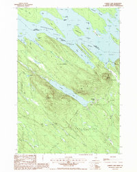
1988 Map of Lambert Lake
USGS Topo · Published 1988About this map
The St Croix River and Spednic Lake define the international boundary between Maine and New Brunswick in this late-twentieth-century study of the Washington County wilderness. The landscape is dominated by the sprawling Chiputneticook Lakes system, featuring numerous inlets and islands like Hardwood Island and Parker Island. Settlement is sparse, centered on the small community of Lambert Lake, which includes a small Cem and several structures near the lake's eastern shore. To the west, the remote Todds Farm sits along the road near the headwaters of Little Brook. Significant topographic features rise above the water-logged lowlands, including Vance Mountain, Tomah Mountain, and the curiously named Pirate Hill. The presence of a Gravel Pit and numerous stream crossings like Simsquish Brook and Walker Brook highlight the logging and resource-based infrastructure typical of the Maine North Woods.
Find a feature on this map
50 named features on this map. Tap any name to fly to it.
Don’t see what you’re looking for? This feature index may not catch every label — zoom into the map to look around manually.
Map Details
Editions of this 1988 Lambert Lake Map
This is the sole edition of this map. No revisions or reprints were ever made.
Other maps of this area

1930 · Vanceboro
USGS Topo · 1:48,000

1933 · Vanceboro
USGS Topo · 1:62,500

1940 · Waite
USGS Topo · 1:62,500

1940 · Forest
USGS Topo · 1:62,500

1940 · Kellyland
USGS Topo · 1:62,500

1942 · Kellyland
USGS Topo · 1:62,500

1942 · Waite
USGS Topo · 1:62,500

1942 · Forest
USGS Topo · 1:62,500

1957 · Fredericton
USGS Topo · 1:250,000

1963 · Fredericton
USGS Topo · 1:250,000
Featured Places
- Vanceboro, ME
- Codyville Township, ME
- Hillgove Township, ME
- Lambert Lake Township, ME
- Forest Township, ME