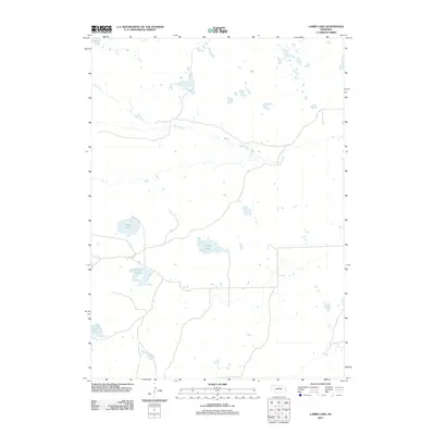
2011 Map of Lambs Lake
USGS Topo · Published 2011About this map
Holt Creek meanders through the heart of this North Central Nebraska landscape, defining a terrain shaped by the Sandhills' unique hydrology. This 2011 survey captures a quiet, aquatic-rich region dominated by numerous water bodies including Lambs Lake, Overton Lake, and Brown Lake. The network of local roads and property boundaries provides a clear view of the rural land divisions and accessibility in this part of Holt County. For those researching the environmental history or geography of the area, the map preserves the exact positions of surface water features like Clear Lake and Frazier Lake as they appeared at the start of the decade.
Find a feature on this map
6 named features on this map. Tap any name to fly to it.
Don’t see what you’re looking for? This feature index may not catch every label — zoom into the map to look around manually.
Map Details
Editions of this 2011 Lambs Lake Map
This is the sole edition of this map. No revisions or reprints were ever made.
Other maps of this area

1955 · O'Neill
USGS Topo · 1:250,000

1959 · O'Neill
USGS Topo · 1:250,000

1969 · O'Neill
USGS Topo · 1:250,000

1981 · Swan Lake
USGS Topo · 1:24,000

1981 · Bruner Lake
USGS Topo · 1:24,000

1981 · Stonehouse Ranch NE
USGS Topo · 1:24,000
1982 · Cottonwood Lake
USGS Topo · 1:24,000

1982 · Sybrant
USGS Topo · 1:24,000

1982 · Dora Lake
USGS Topo · 1:24,000
1982 · Pony Lake
USGS Topo · 1:24,000