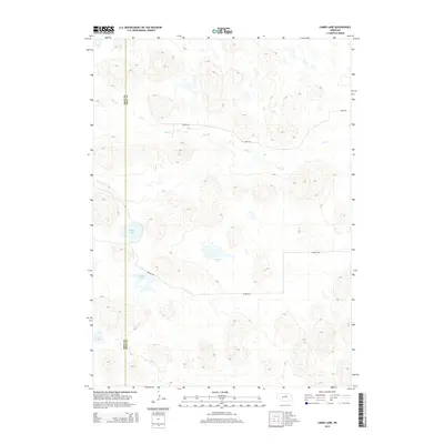
2014 Map of Lambs Lake
USGS Topo · Published 2014About this map
Lambs Lake sits at the center of this 2014 terrain study, characterizing a landscape defined by isolated water bodies and shifting prairie elevations along the border of Rock and Holt counties. The area is sparsely developed, with human activity primarily marked by a grid of rural routes such as 864th Rd and Benton Rd that navigate around the numerous basins and wetlands. Significant hydrological features include Frazier Lake in the north and the winding path of Holt Cr which drains toward the east. This section of the Nebraska Sandhills shows a distinct drainage pattern where Overton Lake and Brown Lake occupy deep depressions amidst the dunes. The lack of concentrated settlements or industrial infrastructure emphasizes the region's historical reliance on ranching and natural water sources.
Find a feature on this map
9 named features on this map. Tap any name to fly to it.
Don’t see what you’re looking for? This feature index may not catch every label — zoom into the map to look around manually.
Map Details
Editions of this 2014 Lambs Lake Map
This is the sole edition of this map. No revisions or reprints were ever made.
Other maps of this area

1955 · O'Neill
USGS Topo · 1:250,000

1959 · O'Neill
USGS Topo · 1:250,000

1969 · O'Neill
USGS Topo · 1:250,000

1981 · Swan Lake
USGS Topo · 1:24,000

1981 · Bruner Lake
USGS Topo · 1:24,000

1981 · Stonehouse Ranch NE
USGS Topo · 1:24,000
1982 · Cottonwood Lake
USGS Topo · 1:24,000

1982 · Sybrant
USGS Topo · 1:24,000

1982 · Dora Lake
USGS Topo · 1:24,000
1982 · Pony Lake
USGS Topo · 1:24,000