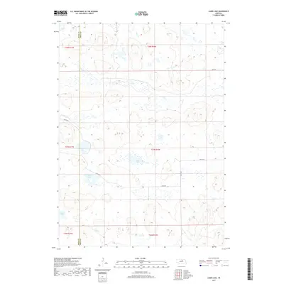
2017 Map of Lambs Lake
USGS Topo · Published 2017About this map
Lambs Lake and a series of nearby wetlands characterize this pocket of the Nebraska Sandhills, documented here in the early 21st century. The landscape is defined by its hydrology, with Holt Cr winding through the northern sections while several isolated water bodies including Overton Lake, Brown Lake, and Frazier Lake dot the depressions between dunes. The map highlights the sparse human imprint on this region, primarily restricted to a straight-line grid of secondary routes like Benton Rd and 466th Ave. The western edge of the quadrangle follows the county line between Rock and Holt counties, a boundary that cuts through the open range and occasional cattle-country infrastructure. For researchers, the map provides a precise view of the water table and terrain as it existed before contemporary shifts in land use or environmental change.
Find a feature on this map
16 named features on this map. Tap any name to fly to it.
Don’t see what you’re looking for? This feature index may not catch every label — zoom into the map to look around manually.
Map Details
Editions of this 2017 Lambs Lake Map
This is the sole edition of this map. No revisions or reprints were ever made.
Other maps of this area

1955 · O'Neill
USGS Topo · 1:250,000

1959 · O'Neill
USGS Topo · 1:250,000

1969 · O'Neill
USGS Topo · 1:250,000

1981 · Swan Lake
USGS Topo · 1:24,000

1981 · Bruner Lake
USGS Topo · 1:24,000

1981 · Stonehouse Ranch NE
USGS Topo · 1:24,000
1982 · Cottonwood Lake
USGS Topo · 1:24,000

1982 · Sybrant
USGS Topo · 1:24,000

1982 · Dora Lake
USGS Topo · 1:24,000
1982 · Pony Lake
USGS Topo · 1:24,000