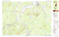
1982 Map of Lancaster
USGS Topo · Published 1983About this map
The Connecticut River serves as the winding border between New Hampshire and Vermont in this 1982 survey, defining the industrial and social character of the valley. To the east, Lancaster stands as a significant hub near the confluence of the Israel River, while to the south, the village of Whitefield marks the southern limit of the study. The landscape is dotted with small settlements like Grange, Riverton, and South Lunenburg, connected by the historical tracks of the Maine Central Railroad and the Boston and Maine Railroad. High ground is anchored by Prospect Mtn within Weeks State Park, where a Lookout Tower overlooks the river valley. The map reveals the era's educational and religious landscape through landmarks like the White Mountains Regional High Sch and St Matthews Ch, alongside numerous family-named hills and brooks that reflect the region's deep-rooted rural history.
Find a feature on this map
87 named features on this map. Tap any name to fly to it.
Don’t see what you’re looking for? This feature index may not catch every label — zoom into the map to look around manually.
Map Details
Editions of this 1982 Lancaster Map
2 editions found
Other maps of this area

1893 · Mt. Washington
USGS Topo · 1:62,500

1896 · Mt. Washington
USGS Topo · 1:62,500

1900 · Whitefield
USGS Topo · 1:62,500

1920 · Guildhall
USGS Topo · 1:62,500

1930 · Percy
USGS Topo · 1:62,500

1931 · Guildhall
USGS Topo · 1:48,000

1931 · Littleton
USGS Topo · 1:62,500

1932 · Littleton
USGS Topo · 1:48,000

1933 · Guildhall
USGS Topo · 1:48,000

1934 · Percy
USGS Topo · 1:62,500