
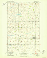
1949 Map of Landa
USGS Topo · Published 1966About this map
The Souris River valley dominates this North Dakota landscape, showing the river controlled by Dam No 357 and flowing through the expansive Lower Souris National Wildlife Refuge. Situated just south of the Manitoba-North Dakota international boundary, the small settlement of Landa serves as a local hub along the Great Northern railroad line. The map captures the organized rural structure of Bottineau County in the late 1940s, where small community centers are identified by landmarks like School No 1, School No 2, and the Zion Ch. Genealogists will find particular value in the clearly marked Landa Cem and Westhope Cem, while the inclusion of various Gravel Pits reflects the local industry and natural resource extraction of the era.
Find a feature on this map
18 named features on this map. Tap any name to fly to it.
Don’t see what you’re looking for? This feature index may not catch every label — zoom into the map to look around manually.
Map Details
Editions of this 1949 Landa Map
This is the sole edition of this map. No revisions or reprints were ever made.
Other maps of this area

1949 · Landa SW
USGS Topo · 1:24,000

1950 · Landa
USGS Topo · 1:24,000

1950 · Landa SW
USGS Topo · 1:24,000

1951 · Westhope SE
USGS Topo · 1:24,000
1951 · Westhope
USGS Topo · 1:24,000

1954 · Landa SE
USGS Topo · 1:24,000

1954 · Roth
USGS Topo · 1:24,000

1954 · Minot
USGS Topo · 1:250,000

1958 · Minot
USGS Topo · 1:250,000

1980 · Bottineau
USGS Topo · 1:100,000