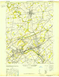
1947 Map of Langhorne
USGS Topo · Published 1947About this map
Neshaminy Creek carves a winding path through this portion of Bucks County, anchoring a landscape where colonial-era settlements met the industrial demands of the mid-20th century. The area is defined by a dense concentration of educational and religious institutions, such as George School, St Andrews Ch, and St Marys Manor Sch, reflecting the deep-seated community roots of the region. The transport network is particularly prominent, featuring the Reading (Newtown Branch) and the Trenton Cut-Off, alongside aviation landmarks like Silver Star Airport.
Find a feature on this map
55 named features on this map. Tap any name to fly to it.
Don’t see what you’re looking for? This feature index may not catch every label — zoom into the map to look around manually.
Map Details
Editions of this 1947 Langhorne Map
This is the sole edition of this map. No revisions or reprints were ever made.
Other maps of this area

1890 · Lambertville
USGS Topo · 1:62,500

1890 · Doylestown
USGS Topo · 1:62,500

1890 · Burlington
USGS Topo · 1:62,500

1891 · Lambertville
USGS Topo · 1:62,500

1891 · Doylestown
USGS Topo · 1:62,500

1893 · Germantown
USGS Topo · 1:62,500

1893 · Burlington
USGS Topo · 1:62,500

1894 · Lambertville
USGS Topo · 1:62,500

1894 · Germantown
USGS Topo · 1:62,500

1896 · Germantown
USGS Topo · 1:62,500
Featured Places
- Philadelphia, PA
- Bensalem Township, PA
- Middletown Township, PA
- Lower Makefield Township, PA
- Lower Southampton Township, PA