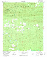
1980 Map of Langley
USGS Topo · Published 1981About this map
The Cossatot Mountains and the winding course of the Little Missouri River define this corner of Pike and Montgomery Counties. At the heart of the area lies the settlement of Langley, where Langley Hall Ch serves as a local landmark. The landscape is heavily shaped by the presence of the Ouachita National Forest and the Caney Creek State Wildlife Management Area, showing a transition from timbered ridges like Fancy Hill Mtn and Pryor Mountain down to the reservoir waters of Lake Greeson.
Find a feature on this map
41 named features on this map. Tap any name to fly to it.
Don’t see what you’re looking for? This feature index may not catch every label — zoom into the map to look around manually.
Map Details
Editions of this 1980 Langley Map
This is the sole edition of this map. No revisions or reprints were ever made.
Other maps of this area

1906 · Caddo Gap
USGS Topo · 1:125,000

1936 · Athens
USGS Topo · 1:48,000

1936 · Glenwood
USGS Topo · 1:48,000

1942 · Glenwood
USGS Topo · 1:62,500

1942 · Athens
USGS Topo · 1:62,500

1949 · Glenwood
USGS Topo · 1:62,500

1955 · Little Rock
USGS Topo · 1:250,000

1956 · Little Rock
USGS Topo · 1:250,000

1960 · Little Rock
USGS Topo · 1:250,000

1964 · Little Rock
USGS Topo · 1:250,000