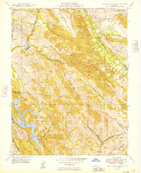
1949 Map of Las Trampas Ridge
USGS Topo · Published 1949About this map
St Marys College and the surrounding hills of the Laguna de los Palos Colorados land grant dominate the northwestern portion of this mid-century survey. The landscape transitions from the residential and agricultural pockets of the San Ramon Valley, where Alamo and Danville are situated along the Southern Pacific railroad line, to the steep, undeveloped terrain of Las Trampas Ridge. Significant water resources are represented by the sprawling Upper San Leandro Reservoir in the southwest, into which numerous drainages like Kaiser Creek and Cull Creek flow. Insights into the area's rural transition are visible in features like the Edenvale School (Abandoned) in the southeast and the various unnamed prospects located along Alamo Ridge. The map captures the East Bay before the period of massive post-war suburban expansion, showing a topography still defined by its creeks, canyons, and peaks like Las Trampas Peak.
Find a feature on this map
43 named features on this map. Tap any name to fly to it.
Don’t see what you’re looking for? This feature index may not catch every label — zoom into the map to look around manually.
Map Details
Editions of this 1949 Las Trampas Ridge Map
This is the sole edition of this map. No revisions or reprints were ever made.
Other maps of this area

1896 · Mt. Diablo
USGS Topo · 1:62,500

1897 · Concord
USGS Topo · 1:62,500

1898 · Mt. Diablo
USGS Topo · 1:62,500

1899 · Haywards
USGS Topo · 1:62,500

1906 · Pleasanton
USGS Topo · 1:62,500

1915 · Haywards
USGS Topo · 1:62,500

1915 · Concord
USGS Topo · 1:62,500

1941 · Pleasanton
USGS Topo · 1:62,500

1942 · Concord
USGS Topo · 1:62,500

1942 · Hayward
USGS Topo · 1:62,500