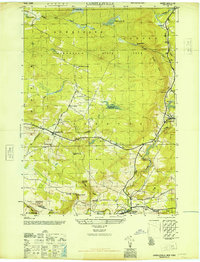
1946 Map of Lassellsville
USGS Topo · Published 1946About this map
Lassellsville and the surrounding township boundaries of Stratford, Oppenheim, and Ephratah are captured in this mid-century Army Map Service study. The landscape is defined by the transition from agricultural valley land to the southern reaches of Adirondack State Park, with numerous small family-named settlements like Scotchbush and Bradtville scattered along the creek beds. Water management is a primary feature of the local infrastructure, evidenced by the St Johnsville Reservoir and the Fort Plain Reservoir. Genealogists will find a dense concentration of historical burial grounds, including the Micheal Cem, Dillaborough Cem, and Christman Cem. The local economy of the era is marked by industrial remnants like Glasgow Mills and the hydrological power of Caroga Creek, providing a clear look at Fulton County's rural development before modern highway expansion.
Find a feature on this map
53 named features on this map. Tap any name to fly to it.
Don’t see what you’re looking for? This feature index may not catch every label — zoom into the map to look around manually.
Map Details
Editions of this 1946 Lassellsville Map
This is the sole edition of this map. No revisions or reprints were ever made.
Other maps of this area

1896 · Fonda
USGS Topo · 1:62,500

1898 · Fonda
USGS Topo · 1:62,500

1898 · Canajoharie
USGS Topo · 1:62,500

1900 · Canajoharie
USGS Topo · 1:62,500

1901 · Lassellsville
USGS Topo · 1:62,500

1902 · Canajoharie
USGS Topo · 1:62,500

1902 · Fonda
USGS Topo · 1:62,500

1903 · Gloversville
USGS Topo · 1:62,500

1903 · Lassellsville
USGS Topo · 1:62,500

1943 · Gloversville
USGS Topo · 1:62,500