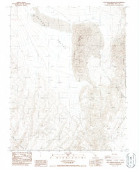
1987 Map of Last Chance Range SW
USGS Topo · Published 1987About this map
Eureka Valley dominates this high-desert landscape in Inyo County, characterized by a dramatic transition from flat dry basins to steep mountain fronts. The massive Eureka Dunes rise from the valley floor, creating a stark geological feature between the Last Chance Range to the east and the Saline Range to the southwest. This 1980s survey illustrates a region shaped by extreme topography and aridity, where the only passage through the steep terrain is found via primitive 4wd tracks and natural gaps like Dedeckera Canyon. At the northern edge of the valley, the Eureka Dry Lake marks the lowest point of this closed basin, serving as a catchment for seasonal runoff from the surrounding peaks. The map provides essential detail for geologists and desert explorers tracing the old routes and landforms of this remote California interior.
Find a feature on this map
8 named features on this map. Tap any name to fly to it.
Don’t see what you’re looking for? This feature index may not catch every label — zoom into the map to look around manually.
Map Details
Editions of this 1987 Last Chance Range SW Map
This is the sole edition of this map. No revisions or reprints were ever made.
Other maps of this area

1908 · Lida
USGS Topo · 1:250,000

1908 · Ballarat
USGS Topo · 1:250,000

1913 · Lida
USGS Topo · 1:250,000

1913 · Ballarat
USGS Topo · 1:250,000

1948 · Death Valley
USGS Topo · 1:250,000

1951 · Waucoba Wash
USGS Topo · 1:62,500

1954 · Death Valley
USGS Topo · 1:250,000

1954 · Goldfield
USGS Topo · 1:250,000

1955 · Goldfield
USGS Topo · 1:250,000

1956 · Death Valley
USGS Topo · 1:250,000