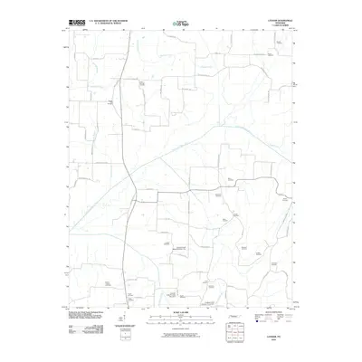
2010 Map of Latham
USGS Topo · Published 2010About this map
The North Fork Obion River winds through this rural landscape in Weakley County, defining the drainage patterns for numerous tributaries like Raccoon Creek and Richland Creek. This area is characterized by a high density of family and community burial grounds, such as Pleasant View Cemetery, Acree Cemetery, and Hatlers Chapel Cemetery, many of which sit alongside quiet country roads like Good Springs Church Rd and New Hope Church Rd. The landscape also features modern water management infrastructure, including Cypress Creek Watershed Dam One and Cypress Creek Number Two Dam. These features illustrate the intersection of historical settlement patterns and the environmental engineering required to manage the wetlands and creek basins that feed into the Obion River system.
Find a feature on this map
70 named features on this map. Tap any name to fly to it.
Don’t see what you’re looking for? This feature index may not catch every label — zoom into the map to look around manually.
Map Details
Editions of this 2010 Latham Map
This is the sole edition of this map. No revisions or reprints were ever made.
Other maps of this area

1950 · Martin
USGS Topo · 1:24,000

1952 · Dresden
USGS Topo · 1:24,000

1952 · Cuba
USGS Topo · 1:24,000

1952 · Water Valley
USGS Topo · 1:24,000

1952 · Mayfield
USGS Topo · 1:62,500

1952 · Water Valley
USGS Topo · 1:62,500
1952 · Lynnville
USGS Topo · 1:24,000

1956 · Mc Connell
USGS Topo · 1:24,000

1956 · Latham
USGS Topo · 1:24,000
1956 · Palmersville
USGS Topo · 1:24,000