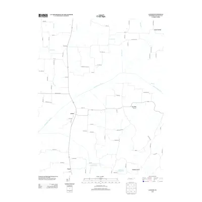
2013 Map of Latham
USGS Topo · Published 2013About this map
The North Fork Obion River meanders across this Weakley County landscape, defining the rural character of the region near the settlement of Latham. In the early 21st century, this area maintained a network of family-named roads and small community hubs like Brundige and Austin Springs. The presence of Good Springs Church Rd and New Hope Church Rd points to the enduring local importance of country churches in these rural Tennessee neighborhoods. Further south, the landscape is punctuated by water management features including Cypress Creek Number Two Lake and Cypress Creek Number Three Lake, which sit near the settlements of Pisgah and Matheny Grove. The map details a sophisticated grid of local connectors such as Wall Rd and McNatt Rd, tracing the residential and agricultural footprint of the day.
Find a feature on this map
76 named features on this map. Tap any name to fly to it.
Don’t see what you’re looking for? This feature index may not catch every label — zoom into the map to look around manually.
Map Details
Editions of this 2013 Latham Map
This is the sole edition of this map. No revisions or reprints were ever made.
Other maps of this area

1950 · Martin
USGS Topo · 1:24,000

1952 · Dresden
USGS Topo · 1:24,000

1952 · Cuba
USGS Topo · 1:24,000

1952 · Water Valley
USGS Topo · 1:24,000

1952 · Mayfield
USGS Topo · 1:62,500

1952 · Water Valley
USGS Topo · 1:62,500
1952 · Lynnville
USGS Topo · 1:24,000

1956 · Mc Connell
USGS Topo · 1:24,000

1956 · Latham
USGS Topo · 1:24,000
1956 · Palmersville
USGS Topo · 1:24,000