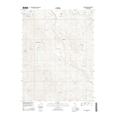
2015 Map of Laughlin Range
USGS Topo · Published 2015About this map
Willits anchors the northern reaches of this Mendocino County landscape, where the valley floor gives way to the prominent Laughlin Range. The 2015 topography reveals a complex network of canyons and peaks, notably Eagle Peak and the aptly named Impassable Rocks. Water shapes the settlement patterns here, with Forsythe Cr and its tributaries like Jack Smith Cr and Mill Cr cutting through the terrain. The presence of Walker Lake, Mud Lake, and Leonard Lake suggests a high-elevation water table that supported early ranching and homesteading efforts. Transportation history is visible through the alignment of Old US-101, which follows the natural contours of the land near Ridge and Walker Valley. This survey captures the rural character of the area, punctuated by private roads and named land features like McGee Canyon and Muir Canyon, reflecting a long history of local land use and family ownership.
Find a feature on this map
49 named features on this map. Tap any name to fly to it.
Don’t see what you’re looking for? This feature index may not catch every label — zoom into the map to look around manually.
Map Details
Editions of this 2015 Laughlin Range Map
This is the sole edition of this map. No revisions or reprints were ever made.
Other maps of this area

1920 · Ukiah
USGS Topo · 1:62,500

1922 · Willits
USGS Topo · 1:62,500

1942 · Willits
USGS Topo · 1:62,500

1943 · Pomo
USGS Topo · 1:62,500

1943 · Boonville
USGS Topo · 1:62,500

1944 · Ukiah
USGS Topo · 1:62,500

1944 · Willits
USGS Topo · 1:62,500

1957 · Ukiah
USGS Topo · 1:250,000

1958 · Ukiah
USGS Topo · 1:24,000
1958 · Ukiah
USGS Topo · 1:62,500