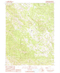
1991 Map of Laughlin Range
USGS Topo · Published 1991About this map
Laughlin Range dominates the eastern portion of this Mendocino County survey, where complex drainage patterns define the local geography. The landscape is characterized by deep canyons and steep ridges, including Baechtel Canyon and Bakers Creek Canyon. Water resources are a central focus of the mapped area, featuring infrastructure such as Morris Dam, a Covered Reservoir, and various natural bodies like Leonard Lake and Walker Lake. These features, along with numerous creeks such as Forsythe Creek and Jack Smith Creek, highlight the watershed management priorities of the region during the late twentieth century.
Find a feature on this map
33 named features on this map. Tap any name to fly to it.
Don’t see what you’re looking for? This feature index may not catch every label — zoom into the map to look around manually.
Map Details
Editions of this 1991 Laughlin Range Map
This is the sole edition of this map. No revisions or reprints were ever made.
Other maps of this area

1920 · Ukiah
USGS Topo · 1:62,500

1922 · Willits
USGS Topo · 1:62,500

1942 · Willits
USGS Topo · 1:62,500

1943 · Pomo
USGS Topo · 1:62,500

1943 · Boonville
USGS Topo · 1:62,500

1944 · Ukiah
USGS Topo · 1:62,500

1944 · Willits
USGS Topo · 1:62,500

1957 · Ukiah
USGS Topo · 1:250,000

1958 · Ukiah
USGS Topo · 1:24,000
1958 · Ukiah
USGS Topo · 1:62,500