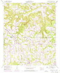
1949 Map of Lawrence Cove
USGS Topo · Published 1977About this map
Brindley Mountain dominates this mid-century landscape on the border of Morgan Co and Cullman Co, Alabama. The terrain is defined by the Tennessee Valley Divide, with numerous branches and creeks such as Cotaco Creek and Ryan Bridge cutting through the hollows. Small agrarian settlements like Center Dale and Fairview are connected by a network of rural roads that skirt the steep slopes of Self Mountain and Tarkiln Mtn.
Find a feature on this map
71 named features on this map. Tap any name to fly to it.
Don’t see what you’re looking for? This feature index may not catch every label — zoom into the map to look around manually.
Map Details
Editions of this 1949 Lawrence Cove Map
This is the sole edition of this map. No revisions or reprints were ever made.
Other maps of this area

1888 · Cullman
USGS Topo · 1:125,000

1892 · Cullman
USGS Topo · 1:125,000

1936 · Hulaco
USGS Topo · 1:24,000

1936 · Eva
USGS Topo · 1:24,000

1936 · Somerville
USGS Topo · 1:24,000

1936 · Lawrence Cove
USGS Topo · 1:24,000

1936 · Center Grove
USGS Topo · 1:24,000

1936 · Holly Pond
USGS Topo · 1:24,000
1936 · Newsome Sinks
USGS Topo · 1:24,000
1947 · Newsome Sinks
USGS Topo · 1:24,000