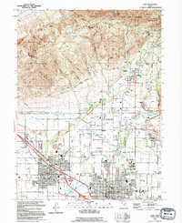
1994 Map of Lehi
USGS Topo · Published 1994About this map
The Traverse Mountains dominate the northern landscape of this region, providing a high-elevation backdrop to the rapidly expanding settlements of Lehi, American Fork, and Highland. This mid-1990s record captures the area as it transitioned from rural agricultural roots into a more suburban corridor. The influence of water management is evident through the intricate network of the Salt Lake Aqueduct, Jordan Aqueduct, and the Murdock Canal, which cut across the benchlands. Local history is anchored by landmarks such as the Museum and Lehi Cem in the west, while the eastern portion highlights the sprawling grounds of the Utah State Training School and the Art Dye Recreation Complex. The Union Pacific railroad corridor and the American Fork River serve as primary north-south and east-west arteries, defining the industrial and natural flow of the valley floor before the era of intensive highway expansion.
Find a feature on this map
70 named features on this map. Tap any name to fly to it.
Don’t see what you’re looking for? This feature index may not catch every label — zoom into the map to look around manually.
Map Details
Editions of this 1994 Lehi Map
This is the sole edition of this map. No revisions or reprints were ever made.
Other maps of this area

1885 · Salt Lake
USGS Topo · 1:250,000

1925 · Ft. Douglas
USGS Topo · 1:125,000

1928 · Ft. Douglas
USGS Topo · 1:125,000

1948 · Timpanogos Cave
USGS Topo · 1:24,000

1948 · Orem
USGS Topo · 1:24,000

1948 · Orem
USGS Topo · 1:62,500

1950 · Orem
USGS Topo · 1:24,000

1950 · Timpanogos Cave
USGS Topo · 1:24,000

1950 · Pelican Point
USGS Topo · 1:24,000
1951 · Pelican Point
USGS Topo · 1:24,000