
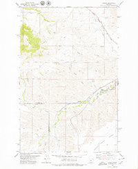
1978 Map of Leiberg Coulee
USGS Topo · Published 1979About this map
Merino Bench dominates the southern portion of this landscape, reflecting the broad, elevated plateaus characteristic of the Judith Basin in the late 1970s. The terrain is deeply incised by a series of north-flowing drainages, most notably Leiberg Coulee and the larger Arrow Creek. These watercourses create a complex network of breaks and draws, such as Big Coulee, which contrast sharply with the flat, productive benches used for dryland farming.
Find a feature on this map
9 named features on this map. Tap any name to fly to it.
Don’t see what you’re looking for? This feature index may not catch every label — zoom into the map to look around manually.
Map Details
Editions of this 1978 Leiberg Coulee Map
This is the sole edition of this map. No revisions or reprints were ever made.
Other maps of this area

1890 · Fort Benton
USGS Topo · 1:250,000

1892 · Fort Benton
USGS Topo · 1:250,000

1897 · Fort Benton
USGS Topo · 1:250,000

1954 · Great Falls
USGS Topo · 1:250,000

1957 · Great Falls
USGS Topo · 1:250,000
1978 · Merino
USGS Topo · 1:24,000
1978 · Stanford
USGS Topo · 1:24,000
1979 · Palisade Butte
USGS Topo · 1:24,000
1979 · Jiggs Flat
USGS Topo · 1:24,000
1979 · Pownal
USGS Topo · 1:24,000